History
Rustington sits on the Sussex coast just over a mile to the east of Littlehampton. There has been human settlement here since the Bronze Age, their evidence uncovered by the local Archaeological Society. The church of St.Peter & St.Paul dates from the 12th century and the west tower remains largely untouched from that time with twin round-headed bell openings, the chancel and north transept are C13th. Farming and agriculture have always been the mainstay of the local economy and it remained unchanged until the mid C19th. This was a time of social change brought about by the opening up of the country by the railways, the dying out of the Feudal system and more social enlightenment. Rustington felt the changes too, the railway line from Brighton to Littlehampton opened in 1846 and a station at Angmering - a mile or so to the north - opened at the same time; the last `Lord of the Manor died and most of his lands were sold off and new industries sprang up notably brick and tile making using local clay; the same soil saw a number of nurseries spring up, not only supplying local needs but exporting crops to Worthing and beyond. After the Second World War saw the gradual increase in Rustington becoming a more residential area; the population increased from 342 in 1851 to 3897 in 1951. There still many old thatched cottages and flint built houses to be found among their more modern counterparts.
 Preceding and during Victorian times (1837 - 1901), Rustington was principally a cattle and arable farming area. In those days farmers paid land taxes levied under the Tithe Commissions Act of 1836. Under that Act all land had to be recorded in the Tithe Maps and Valuation Book, which showed the boundaries of titheable (taxable) land and the amount of the tithe which had to be paid to the Parish. Only land producing crops was titheable: roads and waste land was not, so it was in a landowner's interest to see that details were accurate. Tithe Commissioners could, and did, challenge landowners under Oath in cases of dispute.
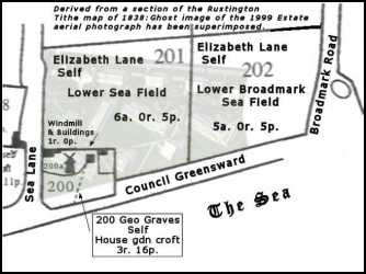 As a result of this system of land recording the Tithe Book with its maps became a very important document in every Parish and, in essence, were the fore-runners of the Ordnance Survey maps of today.
The Rustington Tithe Map 1838/39 shows that our Parish was no exception. Below is an enlargement of fields 200 - 202 which are of are of particular significance to all that follows below.
As a result of this system of land recording the Tithe Book with its maps became a very important document in every Parish and, in essence, were the fore-runners of the Ordnance Survey maps of today.
The Rustington Tithe Map 1838/39 shows that our Parish was no exception. Below is an enlargement of fields 200 - 202 which are of are of particular significance to all that follows below.
1. The land which was to become Millfield Overstrand Estate, Seafield Road and the Princess Marina Home.
Seafield FarmElizabeth Lane was the landowner of the 4 fields comprising Seafield Farm between the southern ends of Sea Lane and Broadmark Lane from 1815 - 1846, according to the 1838 Rustington tithe map.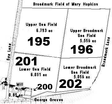 In total these fields measured just over 23 acres. There was also a small plot of land adjacent to the south western corner of these fields owned by George Graves, the miller, on which he had a house, garden and small croft, 0.85 acres in all, and a further 0.25 acre plot on which the Seafield Windmill, its office and outbuildings stood.
For more detail on the history of the mill click on this link to the Sea Field Mill.
In total these fields measured just over 23 acres. There was also a small plot of land adjacent to the south western corner of these fields owned by George Graves, the miller, on which he had a house, garden and small croft, 0.85 acres in all, and a further 0.25 acre plot on which the Seafield Windmill, its office and outbuildings stood.
For more detail on the history of the mill click on this link to the Sea Field Mill.
The Ordnance Survey Map 1912 The 3 parcels of land which were eventually owned by the LMAB for the Millfield Convalescent Home and its grounds have been outlined on the map above. Apart from the southern boundary, which was adjusted later to allow for the Council Greensward, the consolidated plot measures about 7.6 acres.
Fields 200 and 201 of Elizabeth Lane's Seafield Farm together with the Graves property described above were destined to become the site of the Millfield Convalescent Home built in 1902/3 by the Metropolitan Asylums Board.
However, between 1838 and 1898 Seafield Farm changed hands to the Urlin family.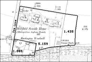 Thus it was Mr. R. Denny Urlin who, in 1898/99, sold 57#189; acres of Lower Sea Field to the London Metropolitan Asylums Board. The 1 acre plot on which the Sea Field Mill and George Grave's house and out-buildings stood and a further 1.43 acres of Lower Broadmark Sea Field was added to the property later. The balance of approximately 16 acres of the original 4 Sea Fields were sold for the Seafield Road development and the Princess Marina Home.
This is where the history of our estate really began - the London Metropolitan Asylums Board were looking for land to build a Convalescent Home for children. They favoured Rustington where it was considered the sea air and mild climate would be of great benefit in treating children, mainly from London, who were suffering from certain classes of illness resulting from poverty and overcrowding. It entailed the selection of a suitable site, acquisition of the necessary land, construction of the buildings and all the organisation of staffing and facilities that followed. It was this same block of land, 160 years later, after the demolition of the Home in 1958, which was purchased by George Wimpey and Co for the development of Millfield Overstrand Estate as it is today. It is a very interesting phase of our history and we are very grateful to Catherine McGuinness, one of our residents, who has taken much time and trouble to research the records of the London Metropolitan Authority and contribute towards the following section on the Millfield Convalescent Home.
The Workhouse often conjures up the grim world of Oliver Twist, but its story is a fascinating mix of social history, politics, economics and architecture. This site, workhouses.org.uk, is dedicated to the workhouse its buildings, inmates, staff and administrators, even its poets...